By Sofi Gratas & Martin Matheny
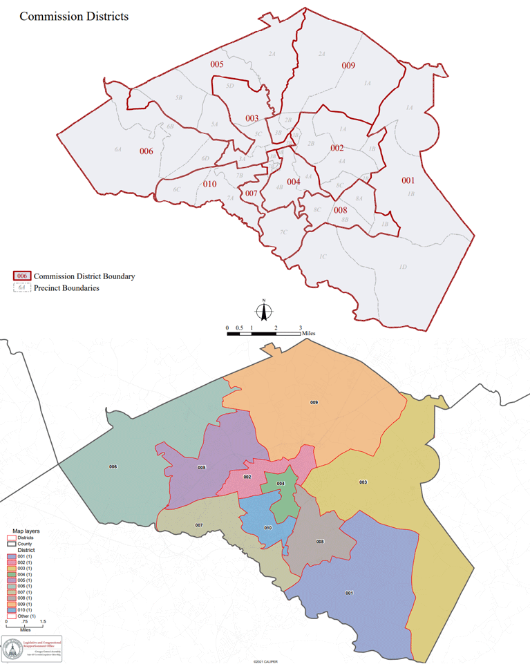
A proposed map of Athens-Clarke County Commission Districts could make major changes to the county’s political landscape. The new proposal, which was released late Thursday by Republican state legislators representing the Athens area, seems to draw three commissioners out of their districts.
Major Changes
Those three commissioners – District 3’s Melissa Link, District 5’s Tim Denson, and District 7’s Russell Edwards – are all up for re-election this year. Denson and Edwards were first elected in 2018; Link is in her second term.
A preliminary analysis of the proposed map indicates that all three commissioners have been drawn into even-numbered districts. If the map passes and those three lawmakers choose to run in their new districts, they couldn’t do so until those districts are on the ballot in 2024.
The city of Winterville will also change representatives under the proposed map. Currently represented by District 1’s Patrick Davenport, Winterville would be part of District 3 under the new map. The new District 3 in the proposed maps would become a sprawling district covering much of eastern Clarke County.
 In-town neighborhoods would also see major changes. Much of the traditionally left-leaning Boulevard, Cobbham, and Normaltown neighborhoods seems to have been removed from Districts 3 and 5 and folded into a new District 2.
The Five Points area has also been realigned. District 7, which included a portion of the historic neighborhood, is now redrawn to exclude Five Points, taking some of the southwestern Clarke County voters currently in District 10. District 10 has been shifted to share much of Five Points with the 4th District, which has also grown to include more of downtown Athens.
“More geographically compact,” say GOP lawmakers
In a joint statement, the four Republican members of the General Assembly who represent Athens – Reps. Houston Gaines and Marcus Wiedower and Sens. Bill Cowsert and Frank Ginn – said, “Instead of carving up communities of interest to protect incumbents, we took the approach of keeping neighborhoods and communities of interest whole to reach equal population in each commission district.”
The quartet of state lawmakers also say that their proposal creates four commission districts where white residents make up less than half of the population.
The GOP lawmakers noted in their statement that ACC commissioners were unable to reach consensus on a proposed map.
“Political skullduggery”
Many local elected officials and political observers are skeptical of the Republican lawmakers’ claims, however.
“It is stated that the maps preserve ‘communities of interest’, which is not true,” Mayor Kelly Girtz said on Facebook. “The real reason is political skullduggery. If they can’t win on the field, they tilt the field.”
District 3’s Melissa Link — one of three commissioners who will be unable to run for re-election this year if the new maps pass — said the decision would cause “utter chaos” for residents.
“The state delegation has presented a map that has been created in secret & undergone zero public input,” Link said on Facebook. “Good luck figuring out who will be your representative on the Athens-Clarke County Commission come Jan 1, 2023. It’s been an honor & a pleasure representing you.”
Another commissioner potentially drawn out of his district, Tim Denson, tweeted, “we voted and begged all Commissioners to support these so that we didn’t give the state legislature free reign.”
What’s next?
Nothing is decided yet, in terms of new districts for ACC Commissioners. The proposed map is just that – a proposal – and requires approval by both the Georgia House and Georgia Senate. Crafting new local maps for cities, towns, school boards, and counties across the state will be one of the major tasks facing the General Assembly when it convenes for its annual session on Monday.
If the maps are passed, ACC residents can expect to see one or more lawsuits filed to stop the maps from coming into effect.
How we got here
The redistricting process was curtailed this year, due to delays in releasing census data. Because of those delays, a process that often starts in the spring or summer didn’t get underway until fall. That left local governments scrambling to create proposed maps to submit to their legislative delegations.
In Athens-Clarke County, commissioners voted 6 – 2 in October to have the county’s Board of Elections draw a proposed map. In November, commissioners saw the results of that work, a proposed map that made minimal adjustments to the current districts to accommodate shifting populations in the county. Commissioners gave that map their stamp of approval by a vote of 6 – 3. Citing concerns with the hastiness of the project, District 10’s Mike Hamby and District 9’s Ovita Thornton voted against the map. District 4’s Allison Wright also voted against the Board of Elections’ draft map.
The county’s delegation to the General Assembly cited that lack of unanimous consent as justification for submitting their proposed map, which differs radically from the Board of Elections’ proposal.
Read the original story on WUGA.org.


